Data.gov has a “Local Government” (data.gov, 2019b) section among fourteen available topics to obtain data. In the “All Local Government section, as of this writing, there are 17,209 datasets (data.gov, 2019a). Filtering found in the “Organizations” or “Publishers” tab will isolate all the data available for Austin, Texas. Not all U.S. States, cities, and counties are in this resource, which does not indicate the data are not available. A direct way to find local data is to go to the city, state, or county websites. Data.gov is still a practical place to start to view what topics are available and can help with idea generation.
The City of Austin, Texas, has 959 datasets (data.gov, 2019c). The Annual Crime Dataset 2015 is from the data catalog. The same data is obtained directly from The City of Austin (data.austintexas.gov, 2017). The crime data is open to the public and intended to be available and downloadable by anyone computer savvy. The Federal government’s terms of use do not apply to this dataset. Provided is a link to visit Austin, Texas’s open data licensing, which is a modified version of the public data commons licensing policies (austintexas.gov, n.d.). On the webpage is the use policy for Austin open data. The terms cover the licensing of data, 3rd- Parties, information vs. data, existing work, and a public domain dedication that states the public is free to share, copy, create, produce, adapt, modify, transform, and build upon existing data (austintexas.gov, para 5, n.d.).
The Annual Crime Dataset 2015 covers a period of one year from January 1st to December 31st, 2015. It has all the crimes described as (Part 1) in the city of Austin (data.gov, 2018). The Austin police department records generate the data and provide a disclaimer about the data. The data may differ from official crime data, and there are differences in time, collection, and sources of data. And the police department does not take any liability for the public use of this data (data.gov, para 1, 2018).
The data is available in four digital formats: CSV, RDF, JSON, and XML (data.gov,2018). There is a link to visit the datasets source page and is located on the data.austintexas.gov website. On the website, there is an interactive dashboard to visualize the data in the web browser (data.austintexas.gov, 2017). There are 13 variables and 38,573 rows in the dataset. There are eight text-based variables, and the remaining five are numeric. Much of the data is categorical, date-stamped, and geo-coordinate. There is no direct, personally identifiable information. See Figure 1 for a list of the column headers (variables).
Figure 1. Annual Crime Dataset 2015 - Variables
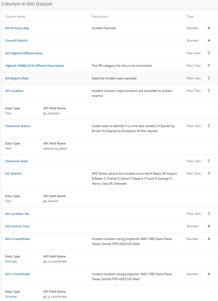
Figure 1 Shows the labeled columns in the dataset with a brief description and type of data (data.austintexas.gov, 2017)
The data is visualized from the website inside the web browser. Below is a quick exploration using the provided web dashboard. Figure 2 shows the highest crime types in Austin, Texas.
Figure 2. Highest Offense Description
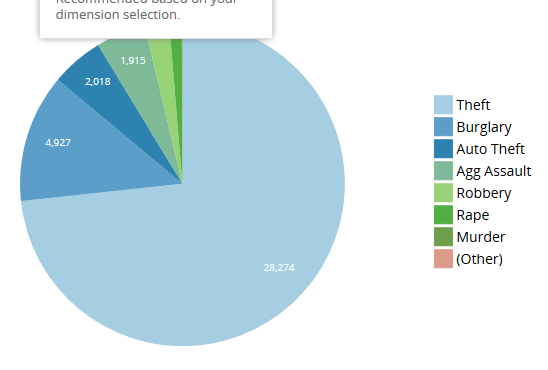
Figure 2. Shows the most top crimes committed in Austin in 2015 (data.austintexas.gov, 2017).
The social justice issue that can benefit from this dataset’s information is the adaptation of public resources to increase police presence in the affected areas based on the geo-location and crime type. Implementing security and counter-measures that protect the citizens is the benefit of seeing the data in aggregate. There is an apparent concentration of crime areas. See Figure 3 and Figure 4.
Figure 3. Top Locations Where Crime was Committed
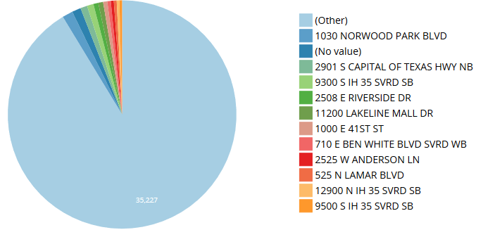
Figure 3 shows the top addresses that have seen the most crime. Theft is highest at Norwood. The “other” makes up all other addresses, which would be too many to chart. Park (data.austintexas.gov, 2017).
Figure 4. Top Zip Codes with Crime
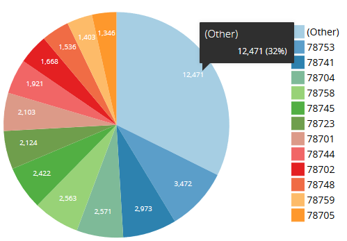
Figure 4 indicates the zip codes of where the crimes have previously been committed in Austin, Texas (data.austintexas.gov, 2017).
The location can also be a social justice issue. With the location zip code and address, it is easy to search for the site on a map and view the image of the location. See Figure 5.
Figure 5. Google Street View
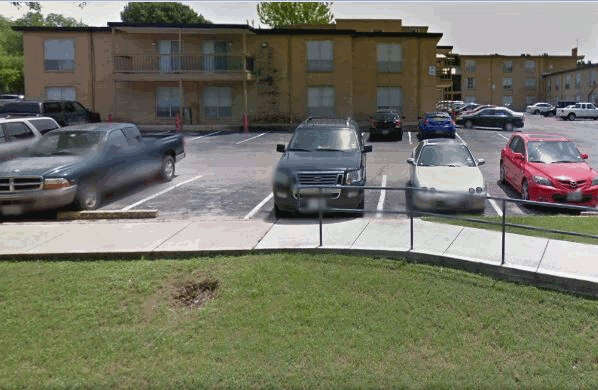
Figure 5 This is the location from the dataset that had 12 crimes committed in 2015 (google.com, 2015). The image is publicly available on Google, and an April 2015 image is available via the filter.
In a random test, the most significant crime location in Austin is at a large mall; however, not all sites are technically public, several randomly searched places are residential units. The location could reveal socio-economic information about the people that are within that area, and potentially a specific group. Targeted theft could occur to lower-earning individuals who can’t afford security systems or targeting more affluent areas.
The dataset has addresses and zip codes of crime locations (Figures 3 & 4 above). Doing a quick satellite image search, above, one can locate the area and do a street view in Google, in many regions of the city, the apartment complex name is visible. There are parked cars (license plates blurred by Google), but the make, model, color of vehicles are visible (DMV records search). The dataset managers did remove the location of rape victims to protect them (indicated in Figure 1). There are no names associated with the crime; however, a public records search of the courthouse could determine names related to the crime type and location. The dataset does protect the privacy of individuals; however, when combined with other data records, a skilled researcher could find more personally identifiable information. We have the date of the crime that can then be used with a text analysis search on social media for words related to the crime type potentially the victim or perpetrator publicly posted something related to the crime such as #iwasrobbed. The majority of addresses looked at in Google Maps are public shopping centers and the apartment complexes, did not find any single-family homes but doesn’t mean there isn’t some in the data.
The ethical implications of the dataset are the identification of areas via zip code and address. The data alone does not identify or single any particular group; however, combining with other datasets, a more detailed analysis could expose ethical issues. Another ethical problem is the Austin police said in the disclaimer that the data might differ from the official APD crime data (data.austintexas.gov, para 1, 2017) If a researcher used this dataset and came to conclusions without researching the “official” Austin Police crime data this is an ethical issue on the researchers part. The other ethical problem is the data does not say if a court conviction was a result of the crime, one can assume, however, the only indicator is the Clearance Status, and that is coded by “cleared by arrest”, “cleared by exception,” and “not cleared” (data.austintexas.gov, 2017) see Figure 1. With the code being the way it is, one could not determine if the crime is falsely accused based on race, demographic, or some other ethically-based issue. Areas of high theft and burglary are identifiable, and with some being a residential complex, insurance companies can use this data when writing home or renters insurance coverage, this could easily be an ethics problem if the insurance company does not disclose this data was used to underwrite the renters or homeowners policy.
References
austintexas.gov. (n.d.). Communications & Public Information Office – City of Austin open data licensing. Retrieved from: http://www.austintexas.gov/coa-open-data-licensing
data.austintexas.gov. (September 21, 2017). Annual crime dataset 2015. Retrieved from: https://data.austintexas.gov/Public-Safety/Annual-Crime-Dataset-2015/spbg-9v94
data.gov. (February 3, 2018). Annual crime dataset 2015. Retrieved from: https://catalog.data.gov/dataset/annual-crime-dataset-2015
data.gov.(2019a). Local – Data catalog. Retrieved from: https://catalog.data.gov/dataset?groups=local#topic=local_navigation
data.gov. (2019b). The home of the U.S. Government’s open data. Retrieved from: https://www.data.gov/
data.gov. (2019c). Data Catalog – City of Austin. Retrieved from: https://catalog.data.gov/dataset?organization=city-of-austin&groups=local
google.com. (April, 2015). Google street view. Retrieved from: https://www.google.com/maps/@30.3080531,-97.7239057,3a,75y,125.46h,86.92t/data=!3m6!1e1!3m4!1slu4c9W8b7A7c47iqfH50EA!2e0!7i13312!8i6656